Historical background
Wallonia has a rich industrial and mining past. The Soil and Subsoil Risks Department assesses the consequences of abandoning tools, underground or surface infrastructures and mining waste.
The consequences can affect both groundwater and surface water, as well as areas as diverse as soil geochemistry, slope and foundation stability, human health and safety, and effects on local flora and fauna.
The impact of Wallonia’s industrial past on our environment remains strong, long after all mining operations have ceased, leaving only the black and green hills known as slag heaps as visible evidence of the region’s past.
Contact: Lorraine Dewaide – 065 61 08 03
One of ISSeP’s missions for Walloon public services is to develop expertise in the assessment and control of chronic risks primarily affecting the stability and quality of the soil and subsoil. In most cases, these risks are related to :
- use of the subsoil (mines, quarries, mining waste, etc.);
- to waste management;
- other past and present human activities…
in a context characterized by
- geotechnical parameters of the soil and subsoil ;
- geochemical characteristics of natural or anthropogenic soil ;
- interactions between the biosphere and the hydrogeological environment…
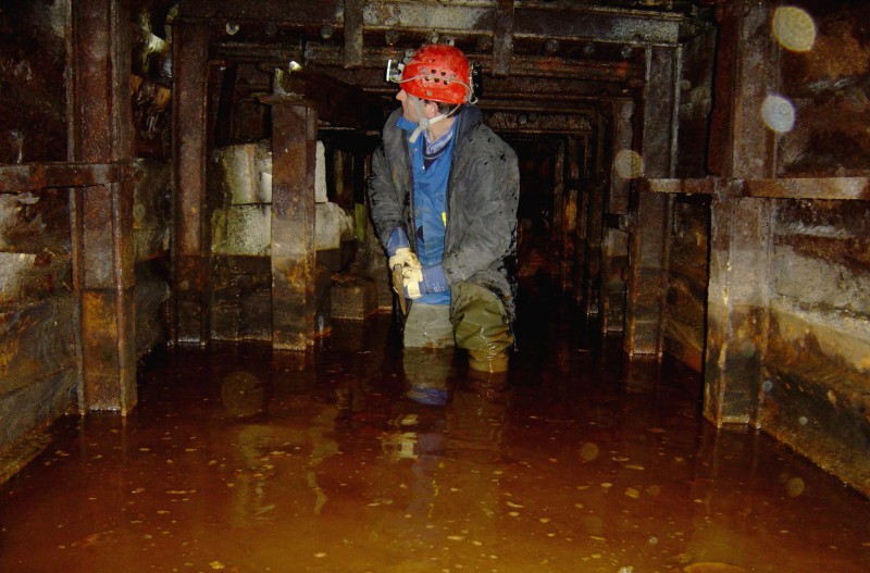
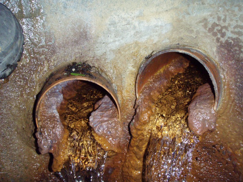
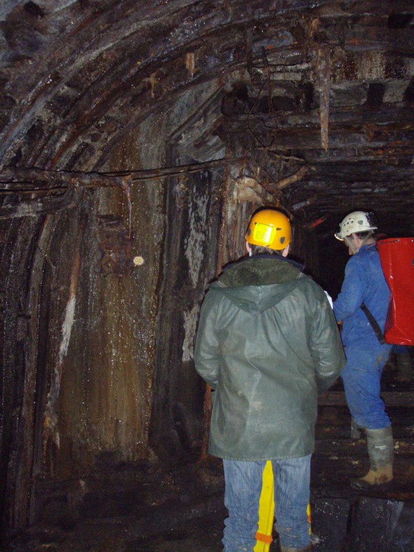
Management of a monitoring network for certain mine outlets
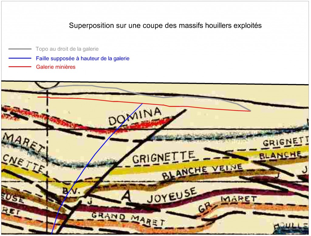
Unfortunately, the consequences of past industrial exploitation are still being felt today. This can be brutal, as in the case of underground collapses or landslides that reverberate right up to the surface, or when the flow of certain mine outlets is interrupted, resulting in water hammering and flooding, or more perniciously, when chemical pollution of groundwater or surface water is observed more than half a century later… The Saint-Vaast collapse in 2009 is another unfortunate example of the need to monitor abandoned mine workings. One way of doing this is to set up a monitoring and warning network based on piezometric and flowmeter measurements, such as the one in the North Liège area, the Haine basin or the Saint-Vaast basin. These networks enable us to better understand the impact of climatic hazards on hydrogeological fluctuations in these areas, and thus guard against the risk of flooding or collapse. These networks are currently the only tool enabling SPW to anticipate the measures to be taken in the event of new threats.
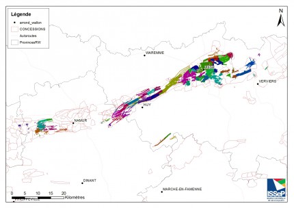
Mining concession withdrawal program
The withdrawal of former mining concessions is one of SPW’s current priorities. Our support program is based on a number of concrete actions, such as assistance in drawing up files for securing former mining outlets, expert advice when submitting technical opinions, assistance in verifying cartographic data, and assistance in visiting and securing former mining structures.
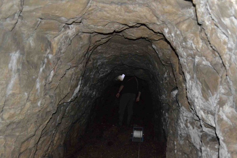
Hazard mapping
Over the past 15 years, SPW has collected or commissioned the collection of a large amount of data relating to the subsoil. This enables its agents to identify and locate more or less precisely geological formations and certain known objects (such as mine shafts, underground quarries, karstic cavities) in order to provide reasoned opinions when applying for permits. However, the geotechnical threat posed by these objects is only defined on a case-by-case basis, depending on the case and the type of object concerned. Yet the nuisance caused by these objects obeys the same laws of soil and rock mechanics, and has obvious similarities. This augurs well for a possible “generalization”.
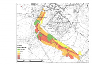
This is why ISSeP and the Walloon Geological Survey have been working since 2013 to develop a method for assessing and mapping geotechnical hazard zones induced by underground objects, based on the French methodology for risk prevention plans. By 2016, the aim is to produce a qualitative map of the Walloon region, showing the geographical areas influenced by the potential damage these objects can cause on the surface.
The local level of hazard will be assessed on the basis of the specific characteristics of the objects under consideration, as well as the geological, hydrogeological and geomechanical contexts surrounding and overlying them down to the surface.
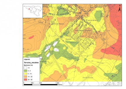
In order to better characterize these objects and their contexts, the ISSeP has collected and compiled the data currently available within the SPW. This work should lead to the mapping of surface formations, a necessary and indispensable preamble to credible mapping of geotechnical hazard zones.
In addition, an effort was made to compile missing or incomplete data, such as coal vein tracings, boreholes and horizons crossing the Quaternary.
The Geotechnical Department (DGO1-61) of the SPW has also agreed that ISSeP can access and use its in-situ test data to help describe the contexts of the objects and map the surface formations. In addition, ISSeP and DGO3 have uploaded some of the geotechnical test locations from DGO1-61 to the CIGALE mapping website.
Characterization of risks associated with former mine waste management facilities (IGD)
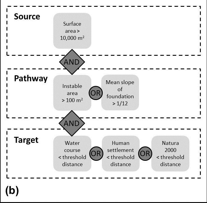
In response to the requirements of Directive 2006/21/EC (the Mining Waste Directive), ISSeP has produced an inventory of IGD from the extractive industry that could have a serious impact on the environment. The methodology integrates indicators into a Geographic Information System (GIS). A coding system has been adopted to characterize the risk level of IGDs according to distance from the target and the particular risks associated with openings or proven cases of self-combustion. The Directive then calls for an assessment of the real risks associated with these sites and the definition of rehabilitation programs.
Post-exploitation monitoring of the Péronnes-lez-Binche and Anderlues gas reservoirs
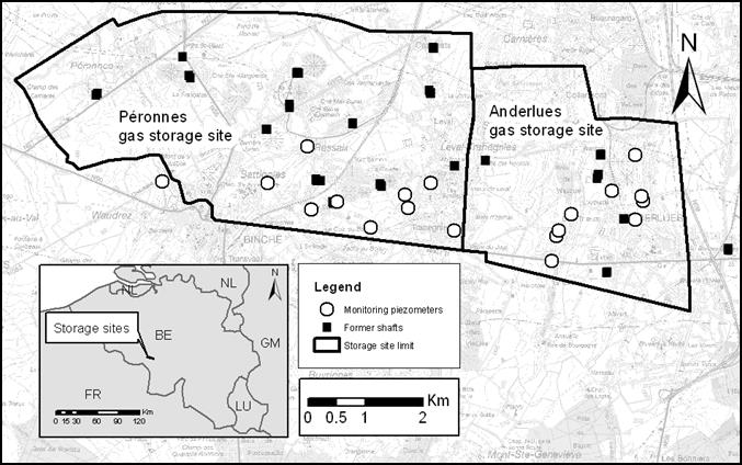
For several years, Fluxys operated part of the Péronnes-lez-Binche and Anderlues mines as underground storage sites for natural gas. Under the agreement between Fluxys, SPW and ISSeP, ISSeP is responsible for the post-operational monitoring and technical supervision of the reservoir sites. Four types of measurement are carried out: monitoring gas pressure in residual voids, monitoring water table rise in residual voids, detecting gas leaks in the vicinity of secure surface structures (former mine access shafts, etc.) and measuring gas pressures and water levels in the vicinity of piezometers installed in surface geological formations.
Georadar technology for road testing
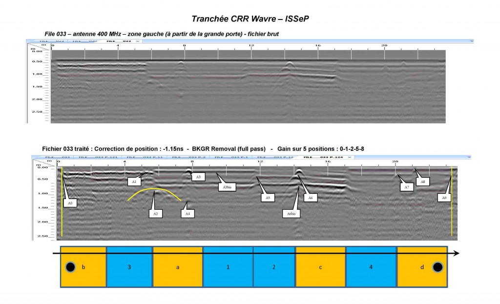
Currently in Belgium, there is a lack of guidelines or standards for the qualitative use of radar in road testing. This approach is based solely on the user’s experience and is therefore not optimal. What’s more, since the customer does not have sufficient information, he cannot judge the quality of the radar measurements or their interpretation.
The use of radar technology as a road investigation method has already been the subject of numerous publications. The method has proved its worth in detecting the thickness of individual layers or coating quality (presence of voids, etc.).
The aim of our intervention, in partnership with CRR, is to define a methodology for the use of georadar in road structure reconnaissance and evaluation. This technique can only be applied in combination with other methods such as geotechnical reconnaissance (drilling, coring, etc.) or other pavement monitoring techniques (falling mass deflectometer or CRR curviameter).
- R. of June 10, 1974 on mine exits and shafts (securing decommissioned shafts);
- mining decree of july 7, 1988
- E.R.W. du 26 juillet 1990 fixant le cahier des charges type déterminant les obligations générales des concessionnaires de mines;
- E.R.W. of April 30, 1992 laying down the procedure and conditions for the withdrawal of a mining title
- Directive 2006/21/EC of the European Parliament and of the Council of March 15, 2006 on the management of waste from extractive industries and amending Directive 2004/35/EC.
- Decree of December 18, 2008 on the management of waste from the extractive industries
- Order of the Walloon Government amending the Order of the Walloon Government of July 4, 2002 adopting the list of projects subject to impact studies and classified installations and activities, with regard to extraction waste management installations.
- Order of the Walloon Government of May 27, 2009 on the sectoral and integral conditions of extraction waste management facilities and on post-closure monitoring, and amending the Order of the Walloon Government of February 27, 2003 setting the sectoral operating conditions for engineered landfill sites.
Within the framework of its grants, ISSeP develops new techniques or new methodologies to meet the specific needs of the administration:
- Assessment of the Péronnes and Anderlues reservoir sites and identification of potential surface gas emissions ;
- Development of a methodology for assessing the risks arising from waste management in the extractive industries. The one proposed by the European Commission’s pre-selection protocol (European Directive 2006/21/EC) has been adapted to Wallonia’s specific requirements by integrating spatial and satellite data into a GIS. This system integrates satellite data. The integration of newly acquired LIDAR data for Wallonia into this GIS has been evaluated.
- As part of a CCN/NBN agreement, development of the georadar technique for road testing